Climate Change Solutions
Nature is essential in fighting climate change. TNC is making sure we’re harnessing its power for a more resilient California.

At The Nature Conservancy (TNC), we know that nature is essential in tackling climate change—and we’re not the only ones. From firefighters to farmers to state agencies, there’s a growing awareness that nature has a critical role to play in creating a climate resilient future. TNC California’s Climate Program is leveraging nature’s powerful ability to sequester carbon, mitigate harmful impacts and protect California’s abundant wildlife and vibrant communities—and we’re supporting others to do the same.
TNC remains committed to honoring the goals of the Paris Agreement, even though the United States withdrew from it in 2025. California is a global leader in addressing climate change, and state and local leadership is more important than ever as we help the U.S. do its part. The world is watching, and the TNC California Climate Program is leading the way to creating a brighter, climate resilient future.
TNC's Climate Plan for California
California is a leader in tackling climate change. Through science, policy and on-the-ground projects, TNC is demonstrating how powerful and essential nature is to this effort.
How we get there:
- Advance Nature-based Solutions Restore key ecosystems like forests and wetlands to sequester carbon, reduce emissions and mitigate harmful climate impacts.
- Make Communities Climate Resilient for People and Wildlife Protect key lands, plan development and drive policies that reconnect nature and keep people out of harm’s way.
- Enable California’s Clean Energy Future Accelerate California’s transition to a decarbonized economy by incorporating nature into energy planning, purchasing and permitting.
Nature-Based Climate Solutions
People created the climate crisis, but we can also create the solution with a critical ally: nature.
Nature-based climate solutions are the ways we protect, manage and restore nature to sequester carbon and defend against harmful climate impacts. Our lands can help us achieve a third of the greenhouse gas reductions needed globally to avoid the most harmful impacts of climate change, making a profound difference for people around the world.
Nature-Based Climate Solutions
-
28M
acres of natural and working lands in California suitable for natural climate solutions
-
514
million metric tons of carbon dioxide equivalent that can be reduced in California with nature by 2050 (more than what 100 million cars produce in a year)
-
$27B
dollars in potential savings compared to traditional grey infrastructure in using nature-based climate solutions to prevent climate-related damages in California
TNC has done the science to show the importance of nature-based climate solutions across California and are focusing on two key ecosystems—forests and wetlands—that have an outsized benefit to fighting climate change, protecting biodiversity, and helping people and wildlife adapt in a rapidly changing world. And we’re putting that science into practice. Across urban, working and natural lands, TNC is advancing nature-based climate solutions through innovative policies, partnerships and on-the-ground projects.

Creating Pathways for Change
Our team works across the state to create the big-picture changes we need to truly leverage the impact of nature for climate. Collaboration with policy makers, community groups, private landowners, tribes, scientists and many others is necessary to successfully transform California’s land protection, restoration and management practices.
We’re working to:
- Drive systems change through innovative policy, such as successfully advocating for the state to create climate targets for natural and working lands.
- Reduce obstacles to increasing the pace and scale of implementing nature-based solutions by reforming and streamlining permitting processes and improving funding.
- Catalyze investment in the protection and restoration of nature to increase disaster resilience for Californians.
- Leverage this work beyond California through partnerships to further joint research, dialogue and policy initiatives.
The Power of Wetlands
California wetlands play a critical role in mitigating the effects of climate change. These ecosystems demonstrate how versatile nature-based climate solutions can be: benefits from wetlands include absorbing floodwaters and buffering against storms, sequestering carbon, supplying critical habitat for native species, cleaning our water and more.
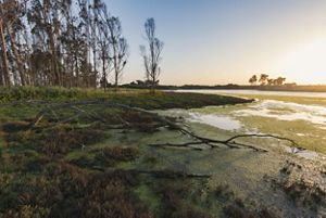


Sea-level Rise: The marshes at protected areas such as Elkhorn Slough absorb floodwaters and act as a buffer against storms and sea-level rise. © Kiliii Yuyan

Protecting Native Species: Iconic California wildlife, such as this endangered southern sea otter, depend on healthy, wild coastlines. © Kiliii Yuyan

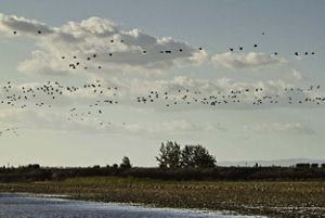
Sequestering Carbon: Cultivating native wetlands and changing agricultural practices can help sequester carbon and support migratory birds in the Delta. © Erika Nortemann/TNC

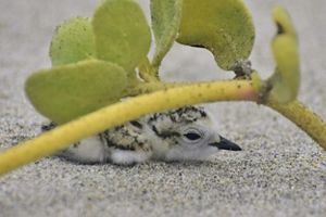
Access to Nature: At places like Ormond Beach, TNC's restoration efforts include both securing habitat for wildlife like this Western snowy plover and increasing public access to nature. © Alissa Goldberg/TNC Photo Contest 2019

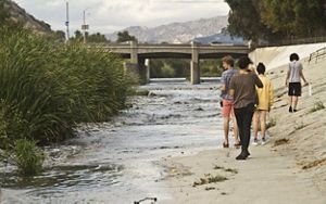
Clean Water: Creating wetlands along the LA River helps clean water while also reducing urban heat, creating habitat and more. © TNC
Unfortunately, most of California’s wetlands have been drained and converted to human land uses such as urban development, transportation infrastructure and agriculture, and our remaining wetlands face multiple challenges. While California has set ambitious goals and has committed noteworthy funding resources, the pace and scale of protection and restoration are not keeping up with the need.
Through science, policy and demonstration projects, TNC is partnering with farmers, local communities, transportation agencies, cities, counties and many more to protect and restore vital wetlands—so they can help protect us.
The Future of Coastal Habitats
-
90%
of California’s wetlands already lost to human land use
-
59%
of the area of California’s coastal habitats is highly vulnerable to 5 feet of sea-level rise
-
55,570
acres of coastal migration space statewide
-
61%
of losses can be mitigated by investing in future habitat
Project Highlights
-
We need a focused and coordinated effort among diverse partners to achieve California’s goals and protect our remaining wetlands. That’s why TNC, the San Francisco Estuary Institute (SFEI), The Pew Charitable Trusts and partners have created the Wetlands for Climate Partnership to leverage complementary strengths in science, policy development, funding, community and on-the-ground wetland conservation. The goal of the partnership is to break down existing barriers to accelerate wetland protection and restoration. We will ensure more intentional, long-range planning and management efforts that benefit wildlife and people, especially those most vulnerable to climate impacts.
California's coastline constitutes a more than 3,000-mile-long treasure, one that is vital to our economy and home to an abundance of plants and animals, many of which exist only in California. With the Pacific Ocean projected to rise five feet in some coastal areas of California by 2100 under business-as-usual carbon emissions, we need to take action. If we want to preserve what remains of our iconic coastline and protect people and wildlife from climate impacts, we need to safeguard the coast of tomorrow by using wetlands to combat the impacts of sea-level rise.
-
With its rich peat soil and more than 750 species of plants and animals, the Sacramento-San Joaquin Delta is vital to maintaining California’s vibrant biodiversity and is a major source of water for nature, cities and agriculture alike. But human impacts and climate change are threatening the Delta, and carbon emissions from current farming practices are contributing to the climate crisis.
However, science shows that there is a path forward. Cultivating native wetlands and changing agricultural land management practices—such as converting corn crops to rice—lead to reduced greenhouse gas (GHG) emissions, increased carbon sequestration, reduced subsidence and improved peat soils. These solutions, often referred to as carbon farming, provide a climate- and habitat-smart strategy to restore the Delta and maintain economic farms and the vital services the region provides.
TNC and our partners are putting this science into practice by using a mosaic approach to farming, cultivating rice and other crops as we restore adjacent wetlands. By the year 2058, this mosaic operation will provide an estimated cumulative reduction in GHG emissions of up to 549,000 metric tons of CO2 equivalent, which is equivalent to the carbon sequestered by planting more than 9 million tree seedlings and letting them grow for 10 years. We’re also restoring 100 acres of wetlands to further reduce GHG emissions, in a process that also leads to improved peat soil and creates critical habitat for birds, such as sandhill cranes.
-
California’s iconic coasts are at risk from sea-level rise and climate-driven storm surges, but the state’s adjoining natural and working lands can play an important role adapting to changing conditions. TNC and the California State Coastal Conservancy’s scientific study, Conserving California’s Coastal Habitat: A Legacy and a Future with Sea Level Rise, contains key strategies to protect our coast, including critical wetlands. For example, protecting and restoring inland areas that adjoin vulnerable coastal areas is a way to ensure California doesn’t lose its coasts. Protecting future coastal habitat today allows plants and animals to migrate as conditions change while also sequestering carbon and enhancing the resilience of coastal areas, nearby communities and agriculture.
A Resilient and Restored Pajaro River Estuary
One of the greatest opportunities to conserve future coastal habitat in California is along the lower Pajaro River Estuary on the central coast. TNC is working with the Land Trust of Santa Cruz County and other partners to restore a recently acquired property and neighboring properties at the Pajaro River Estuary, returning vulnerable agricultural lands to coastal marsh so they can better absorb floodwaters and sea-level rise. This provides habitat for native species and helps protect important adjoining farmland from flooding and storm surges, and we hope it can be a model for other coastal communities.
Prioritizing Nature in Infrastructure Adaptation at Elkhorn Slough
As much as 90 miles of scenic Highway 1 along California’s coastline is at risk of flooding from sea-level rise and storms by 2100 or sooner. In the vibrantElkhorn Slough, flooding already impacts Highway 1, the Elkhorn railway and the amazing coastal habitats and species that reside there. TNC is collaborating with transportation and natural resources agencies on the Highway 1 Elkhorn Slough Corridor Climate Resiliency Project to advance nature-based solutions that adapt vulnerable transportation infrastructure in ways that help protect and restore valuable habitat for important species such as sea otters and migratory birds.
-
TNC is demonstrating the benefits of nature-based solutions in Los Angeles with the Bowtie Wetland Demonstration. By transforming an abandoned railyard into an open space filled with native plants, flowing water and walking paths, this project creates a highly visible model for urban wetland creation and habitat enhancement. It shows how habitat, water treatment, public access and climate resilience can combine in one place. While demonstrating what the future of the Los Angeles River and surrounding region could be, the project also allows TNC to gather important data and lessons learned to accelerate the implementation of nature-based solutions across the state.
Healthy Forests for a Safer California
California’s forests are key in our mission to create a more resilient state. Healthy forests store significant quantities of carbon and water and provide critical habitat for many species. But when extreme fires burn, large quantities of banked carbon are released back into the atmosphere, to the point that our forests could release more carbon than they absorb.
Luckily, we know how to keep our forests healthy and prepare them to withstand severe fires and other threats made worse by climate change. TNC and our partners throughout the West do this through effective forest treatments, which include thinning (meaning the removal of brush or small or unhealthy trees to reduce fuel for fires) followed by beneficial fire. We also apply beneficial fire alone where there is no need to thin the forest before reintroducing fire.


Prescribed fire, cultural fire and managed wildfire are recognized as critical components of the restoration of ecological health and resilience to California’s forests, but these practices can still be challenging to implement. TNC is working hard to scale beneficial fire by:
Collaborating on science studies to understand the barriers to beneficial fire and opportunities to increase the scale of prescribed fire and managed wildfire for resource benefit.
Hosting prescribed fire trainings and events needed to increase the workforce of trained fire professionals and to build a larger, more inclusive workforce.
Growing the public funding, personnel and capital expenditures needed to plan and safely implement larger prescribed fires and more effectively manage wildfire behavior.
Developing policy solutions that address perceived risks of using beneficial fire as a land management tool, including state-backed claims fund and wildfire resilience insurance.
Project Highlights
-
After establishing the preserve in 2010, TNC launched our first forest restoration efforts on these 2,300 acres. To protect the lake’s threatened Lahontan cutthroat trout and reduce the risk of high-severity wildfire, we are applying thinning and prescribed fire. We pair this work with on-the-ground science to understand the impacts of forest treatments on understory plant biodiversity, forest structure and diversity, and fuel loads. We are also working with the Washoe Tribe, the original stewards of this land, who guide and implement these prescribed burns with TNC.
-
In 2015, TNC brought together state, federal and local partners—including the local water utility—for this first-of-its-kind collaboration. The group took the same restoration approach used at Independence Lake and scaled it in a 2,800-acre landscape (that’s 10 times larger). We also collaborated on a science study to quantify how forest treatments would increase water yield and could be leveraged to improve ecological flows for foothill yellow-legged frogs below French Meadows dam.
-
Initiated in 2019, this 275,000-acre project will be the largest forest restoration of its kind in the Sierra. Using the partnership model we honed at French Meadows, we are working with nine partners to restore one of the most critical watersheds in the region. TNC scientists are leading a multi-party monitoring effort to quantify the impacts of forest treatments on habitat for California spotted owl and large trees.
-
Thanks to the scientific credibility and strong partnerships we built up through our work in the Sierra, TNC was invited to work with the U.S. Forest Service to lead the science effort that will guide restoration across the 2.4 million-acre band of forest surrounding Lake Tahoe. The Framework for Resilience developed by the science team was adopted by the state Wildfire and Forest Resilience Task Force to frame forest restoration efforts across the state. The team also developed a novel way to incorporate climate change projections to inform where to invest in forest treatments to improve resilience.
Wildfire Solutions
Reducing catastrophic wildfires is a cornerstone of protecting California, and nature can help us make that a reality. With proactive pre- and post-disaster planning, there is an opportunity to build real resilience in communities across California, using nature to protect people from future risk of wildfires.
Working at the intersection of science, conservation, policy and economics, TNC develops and delivers solutions that catalyze investments in wildfire risk reduction and resilience. We’re joining with partners across the state—from government agencies to insurance companies to Tribal nations—to advance this critical work. With people throughout California focused on the growing risks and costs of wildfire, now is the time to promote visionary but achievable strategies to expand investment in wildfire resilience. Together, we can break California’s cycle of catastrophic wildfire.
Quote: Dan Porter

Addressing the wildfire crisis is a matter of implementation—we know what works, and the state has an action plan. But we can’t execute it without adequate funding.
Project Highlights
-
In 2025, TNC and our partners Sierra Business Council and the Northern Sierra Partnership formed the Wildfire Solutions Coalition, a new statewide coalition that’s organizing a broad base of public support to increase public investment in wildfire resilience. The coalition’s initial focus is to ensure that nature-based climate solutions, including forest and wildfire resilience projects, receive a significant proportion of cap-and-invest revenues during the program’s reauthorization in 2025-2026.
-
In 2018, the small town of Paradise, California, made international news when the Camp Fire killed 86 people, burned 95% of the town’s structures to the ground and caused $16.5 billion in damages. The tragedy was of extraordinary proportions.
During the fire, residents who were unable to leave evacuated to a community park, which provided protection from the flames. As part of their rebuilding process, the town approached TNC to explore how open space could help the community become more resilient as they redevelop while also providing other benefits like habitat and recreational opportunities.
TNC launched two partnerships to develop and test new approaches to (re)development that combine internal and external expertise in fire and ecological science, conservation planning and economic modeling. Our 2022 report, Learning to Live with Fire in Forest Communities, highlights the science and benefits of fire-resilient community design.
-
In 2025, devastating wildfires ravaged the greater Los Angeles area. These were human-ignited fires that started in chaparral, not forests, and they burned across landscapes dominated by shrubs and houses rather than through a forest dominated by trees. Under current extreme drought and wind conditions, chaparral fires can result in explosive events that threaten our lives and communities.
Recognizing the urgency of this threat, TNC is working with partners to highlight tailored approaches to building community resilience to wildfire that support chaparral ecosystems and harness our ability to plan communities so they are less vulnerable to chaparral fire.


Connecting Nature, Protecting Communities
The way we plan our cities and communities can make a huge difference when it comes to building a more climate resilient future. Urban sprawl creates carbon emissions and puts people directly in the way of climate-exacerbated natural disasters like flooding and wildfires. Development also fragments landscapes, harms wildlife, degrades water resources and impacts human health. And California is developing fast: our state lost more than one million acres of natural areas from 2001 to 2017 alone, primarily due to the outward expansions of cities, suburbs and exurbs.
There is a better way to grow our communities, and it means focusing new development in existing communities—not in vital ecosystems—and prioritizing nature in community and infrastructure planning. When we do this, we can improve climate resilience for all living things that call California home.

Building on more than 60 years of leadership in California, TNC uses our scientific and policy expertise; connections with local communities, partners and policymakers; and long history of successful place-based conservation to help incorporate nature into development and community plans. As part of this work, we are implementing an ambitious suite of connectivity projects to protect connected landscapes and reconnect wildlife corridors, creating networks for nature to help wildlife adapt to changing climates.
Project Highlights
-
TNC is leveraging our science to identify priority wildlife corridors and advance wildlife crossing projects, including over and under Interstate-15 in Riverside County, to allow wildlife to safely move. We’re also creating networks for nature by connecting habitats to help California wildlife survive the climate crisis.
-
A quarter century after the original Missing Linkages symposium that brought habitat connectivity to the forefront of conservation thinking in the state, TNC and partners are convening another landmark event. This symposium is part of our efforts to create a vision for a system of connected landscapes and wildlife corridors throughout California and working in coalitions to advance policies, create funding streams and drive implementation to make the vision a reality.
-
We’re working to promote climate-smart housing in existing communities and disincentivizing housing in places that fragment key habitat, put people in harm’s way and contribute to urban sprawl.
-
We’re motivating organizations and governments to create Greenprints in their communities or regions. Greenprints reveal the range of benefits provided by nature in community planning, to inspire decision makers and communities to advance nature-based solutions for vibrant and resilient communities.
-
We’re developing frameworks that integrate conservation and infrastructure planning to both maximize the benefits of conserving nature and also reduce costs and risks to infrastructure projects.
California’s Clean Energy Future
One of the most important and effective ways to fight climate change is to transition from fossil fuels to clean, renewable energy. California is fully committed to this goal, and we’re in an era of transformational change to the energy system as the state works to reach 100% clean energy by 2045.
To make this happen, more clean energy resources and electric transmission need to be built—faster and bigger than ever. Estimates are that 1-3 million acres of land area and sea space could be needed for new clean energy resources to achieve 100% clean energy for our state. This construction could negatively impact land use and biodiversity.
That’s why the clean energy transition needs land-use solutions. TNC is a leader in applying our science and land-use expertise to support policy and planning that advances clean and green energy: energy that is zero carbon and located in areas of low impact to nature.


To support our state’s urgency and ambitious clean energy transition, our team develops new science, planning and policy approaches to add new clean energy resources, reduce the environmental impacts of the energy system and make it less vulnerable to the effects of climate change. Siting energy in ecologically important areas can delay implementation and increase costs, so planning with nature in mind can actually accelerate getting clean energy on the ground and save money.
Throughout our work, TNC is informing a clean energy transition that safeguards nature and delivers clean, safe, reliable and affordable energy for all Californians.
Project Highlights
-
In 2019, TNC published a first-of-its-kind study for California, Power of Place, a report that integrates sophisticated energy modeling with conservation data to demonstrate how California can achieve its clean energy goals while limiting harm to vulnerable ecosystems and factoring in cost and electricity reliability. Since then, TNC has replicated the methodology to show how we can decarbonize in ways that minimize impacts to nature across the entire western United States and nationwide. TNC also led an analysis to identify transmission investments needed to enable low-impact solar development in the San Joaquin Valley, a critical area for advancing the Power of Place—West’s vision.
-
The Mojave Desert plays a leading role in California’s ambitious renewable energy goals. Wind and solar energy installations are becoming an increasingly common sight in the desert. While those projects make important contributions to California’s climate change objectives, they need to be pursued in places and ways that will allow California’s natural habitats to continue thriving.
TNC’s Development by Design approach brings together everyone who depends on the region’s resources in order to ensure a permanent and amicable solution to the desert’s environmental and energy needs. By using TNC’s extensive scientific knowledge of the region, we can take a “Smart from the Start” approach to guide the development process and inform mitigation strategies to ensure that the Mojave Desert remains one of the most wild and least human-modified landscapes in North America.
-
Rechargeable batteries made from lithium are a key part of society’s plan to decarbonize. TNC recently led and published the first study to evaluate the potential impacts to biodiversity and conservation from proposed lithium extraction sites in the continental United States. With specific information about how proposed extraction projects could potentially impact specially designated lands, habitat and wildlife—and approaches to minimize these impacts—policymakers and community leaders have new information to navigate this growing challenge.
-
TNC’s Green Light Study showed that clean and green energy projects in California were permitted 2.5 times faster than clean energy projects proposed on ecologically important land. Through proactive planning that incorporates land and conservation data into energy decisions, California can significantly ramp up renewables and minimize delays while also limiting negative impacts to the natural and working lands.
-
Over the last decade, TNC has been an active supporter of California’s SB 100 with a goal to achieve 100% renewable and zero carbon energy by 2045. California is currently updating the roadmap to achieve this vision, and TNC is bringing our science to these discussions to show how we can achieve multiple goals together, including protecting nature and maximizing energy reliability and affordability.
As California leads the nation in transitioning to a zero-carbon economy, we also have an opportunity to further leverage TNC’s work. The tools and approaches that we are developing and deploying here in California are being adopted far beyond our borders, across North America and the globe.


